For 11 days each spring, families from every corner of the state and every street in the city have been making happy memories at Victoria’s most vibrant community event, the iconic Melbourne Royal Show.
Melbourne Royal Show
Overview
The Melbourne Royal Show is Victoria’s largest and most iconic community event, bringing Victorians together to celebrate world-class agriculture, entertainment, food and fare. The traditional purpose is the display of rural industry, including livestock and produce with its associated competitions and awards, however the show also features food and drink vendors, amusement rides, and a sideshow alley, as well as Showbags. It is organised by The Royal Agricultural Society of Victoria, and has been running since 1848. Each year Melbourne Royal Show attracts attendances of up to half a million people.
Sense Advertising, The Royal Agricultural Society of Victoria’s web agency, asked Mobiddiction to develop the digital map in conjunction with Sense’s digital producer for the project and their graphic design team.
Problem Statement
Before 2024, show visitors used printed paper maps and event schedules to find out where things were and to find their way around the event venue. This has many disadvantages, such as the lead time required for printing maps and the inability to update maps in response to schedule changes or to correct errors. Paper maps also fail to meet current expectations of mapping and navigation given the ubiquitous availability of dynamic mapping on mobile devices which have Google or Apple Maps built in.
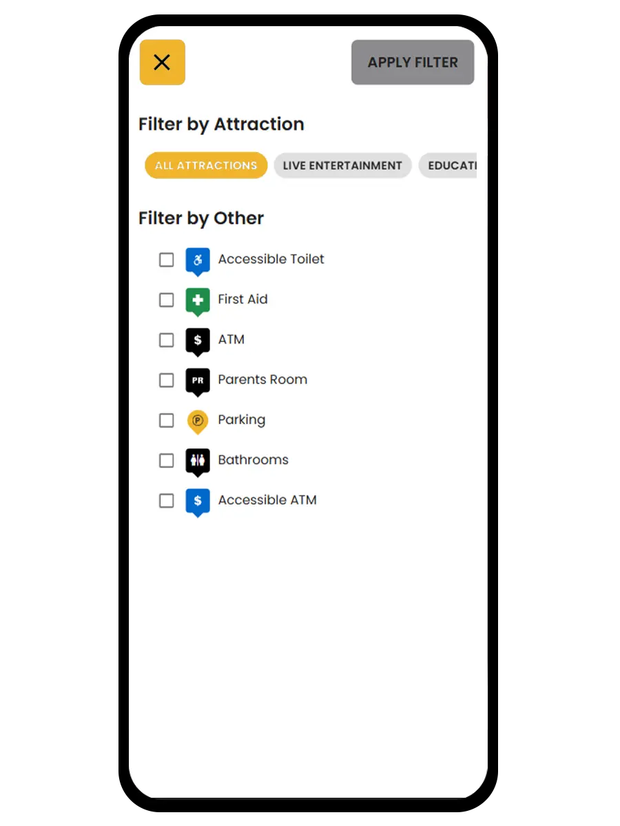
Event visitors reasonably expect to be able to search and categorise events and places on the show map on their phones, and to have “blue dot” navigation available while at the event venue. They also expect navigation or wayfinding, showing them the shortest walking route from where they are to any selected point of interest on the map.
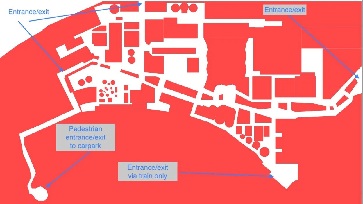
Wayfinding during the event is complicated by event specific access restrictions, such as the temporary boundary fence with entry and exit gates, show infrastructure such as carnival rides and animal enclosures blocking normal access routes, and sections of the venue being closed off to the public during the show.
The Royal Agricultural Society of Victoria and the event have a strong brand and style guide, and the map will need to conform and fit in with all their other digital publications. This, along with the temporary event specific features of the show, means that default Google and Apple maps cannot be used on their own.
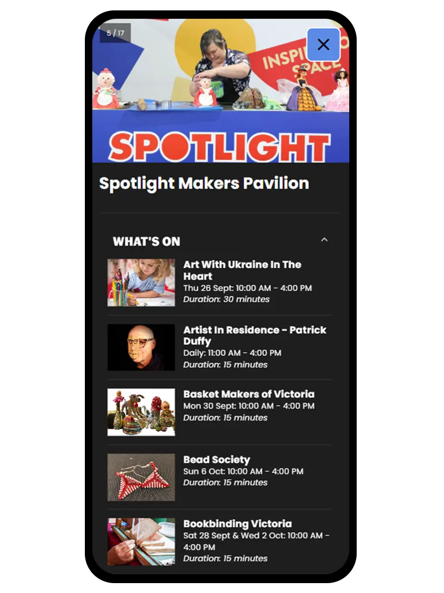
Some of the data to be displayed on the dynamic map is controlled by 3rd parties. The event guide (What’s On) and the carnival ride information are available via APIs, but a lot of the other important points of interest such as food and drink vendors, entrance and exit gates, ATMs, and facilities such as toilets and first aid stations do not have an existing system or database to manage them.
Our Thinking
Mapiddiction solves most of the problems out of the box, and the APIs for the What’s On and Rides data can be implemented as a plugin for Mapiddiction easily. Sense were able provide API documentation and endpoints for the APIs available, and where necessary have those APIs modified or extended to provide accurate GPS locations.
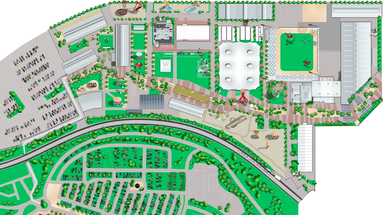
Sense already has a design team familiar with the brand and style guides and who worked on the show website. They could design the image of the map, with assistance and specific requirements from Mobiddiction’s mapping specialists.
The wayfinding and walking directions can be calculated by Mapiddiction’s wayfinding module, based on an accurate “walkable area” map provided by Sense and their on-ground staff.
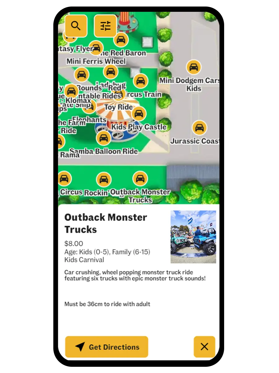
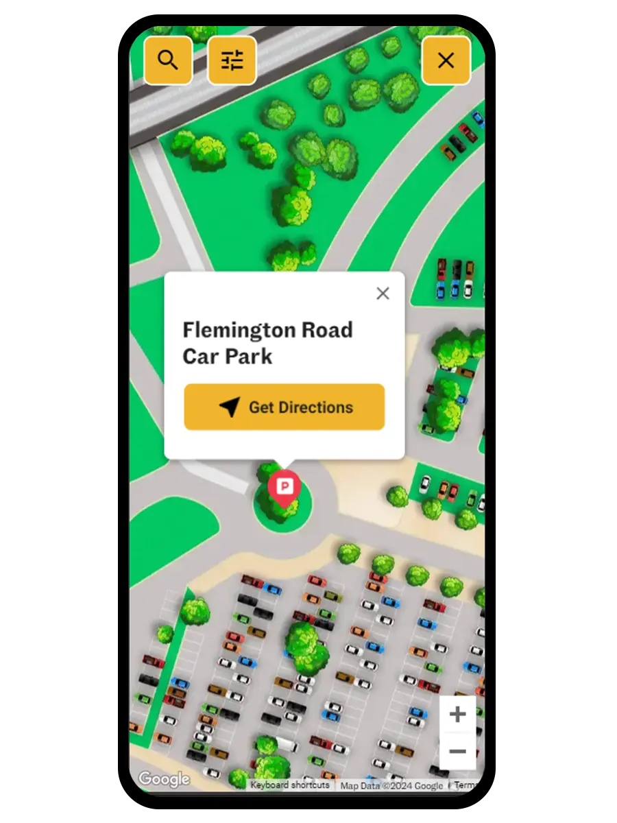
Using a custom map image overlaid on an html/javascript powered GoogleMap would allow us to show a strongly branded map of the event venue, while delivering all the normal geolocation features of a GoogleMap. Using Mapiddiction’s POIs and Labels allows us to draw marker icons and text that automatically resizes as the map is zoomed in and out. The Wayfinding Module lets us deliver event specific walking routes, allowing show visitors to select an event or other point of interest by searching or tapping on screen, and then they can be shown the shortest route to walk to get there from their current location.
Design
Our specialist mapping team at Mobiddiction worked with Sense’s designers to create a branded map image suitable to overlay on a Google Map with the style and colours required by the brand guidelines.
To use this as a pan and zoomable “slippy map”, where you can slide the map around with your fingers on your phone screen, there are some specialised requirements that people who normannly design maps for printing might not be aware of.
Mobiddiction collaborated with Sense’s designers to ensure the following dynamic map constraints were met:
- Sufficient size/resolution so it doesn’t look to pixellated when zoomed right in.
- A file format with transparency to allow the underlying Google Map to show through around the edges of the irregular shape of the venue map.
- A small enough file size to download and cache reasonably. This is a compromise between items 1 & 2 above, and suitable dimensions and compression to keep the file size small.
- Leaving off all text and icons, so they won’t become huge or tiny as the map is zoomed in and out. These will be dynamically overlaid later via the Mapiddiction Platform, so the sizes of text and icons remain readable and consistent across zoom levels.
Sense’s designers also created suitable icons for important event specific POIs. Mapiddictions icon library was used for common items like ATMs, toilets, and first aid stations.
Development
A large part of the work to deliver the map was configuration within Mapiddiction. Once the map image in suitable size and format was created by Sense’s designers collaborating with Mobiddictions map team, it was uploaded to Mapiddiction and calibrated (to ensure that places on the image lined up accurately to the underlying GoogleMap and real GPS coordinates). All the places of interest (POIs) that were not coming from 3rd party APIs were added in appropriate categories as POIs in Mapiddiction, along with uploading or selecting the required icons. This POI database was made available to Sense staff to edit and update as and when required.
The 3rd party APIs were integrated by Mobiddiction, by developing a Mapiddiction plugin, which is the standard way to extend Mapiddiction to communicate with other databases and systems. The plugin polled the What’s On and Rides APIs, and cached resources to minimise additional load on the origin server from thousands of event visitors using the dynamic map each day. For time critical or emergency purposes, both regular and API sourced POIs could be edited by authorised Sense or Mobiddiction staff via the Mapiddiction admin dashboard, and the map would update instantly.
The wayfinding required creation of an accurate “walkable area map”. This was initially based on event plans, and updated and refined by both Sense staff and staff on the ground during event setup. This map stared out as site plans, and was refined by various people using anything from updates of the digital site map file, through pencil annotated notes on a printed version of the map, through to message or phone calls explain required changes. This refined map was then specially formatted by Mobiddictions mapping specialists into a form usable by the Wayfinding Module. The Mapiddiction Wayfinding Module processes the specially formatted walkable areas map in conjunction with the POI database, and can calculate the shortest walking route to any POI from anywhere on the map. It can then display a dotted line on the map from a visitors “blue dot” current location to the selected POI, along with distance, estimated walk time, and even turn by turn directions.
The Experiencer
The map was published on the Melbourne Royal Show website in a form that worked both on desktop and on mobile devices. When a user granted location privileges to the map on their phone, “blue dot” navigation showed their current location, and gave the ability to show navigation directions on the map to any POI selected via tapping an icon or searching/filtering and tapping from a list.
The web-based nature of the map and the capability of the Mapiddiction Platform meant that QR Codes could be created linking directly to a specific POI. This allowed things like food vendors to distribute printed flyers or discount vouchers with QRCodes showing their stall on the map and providing a single click navigation from wherever the user was.
The map was live across the 12 days of the Melbourne Royal Show in Sept/Oct 2024, and was loaded hundreds of thousands of times, with tens of thousands of wayfinding requests.